How far will heavy rain prediction evolve? An interview with the Japan Meteorological Agency on weather prediction technology in 2030
- Social Issues & Advancing Society
- Insurance & Risk Insights
- Sustainability
-
*This is a reprint of an article in SENSOR, the newsletter published by the Tokio Marine Research Institute.
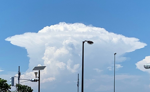
Natural disasters are becoming increasingly severe and frequent. Stationary linear mesoscale convective systems (SLMCS), often responsible for heavy rainfall events, pose significant challenges for prediction. "If we could predict the formation of SLMCS and the paths of typhoons in advance..." Amid such expectations from society, how is Japan's weather prediction technology evolving? In this article, we spoke with Yuji Kitamura, Senior Forecaster, and Yutaka Sasagawa, Senior Coordinator for Numerical Prediction Development Partnerships, both at the Numerical Prediction Division of the Japan Meteorological Agency's Information Infrastructure Department, who are tackling the prediction of SLMCS and typhoons through the technological development of numerical weather prediction, which is the foundational data for meteorological information applied in weather prediction and disaster risk reduction.
Japan Meteorological Agency (JMA) Numerical Weather Prediction (NWP) Strategic Plan Toward 2030
There is growing social interest in prediction technology for SLMCS and typhoons. Please tell us about the initiatives being undertaken at the JMA to advance prediction technology and the future prospects for this technology.
In recent years, there has been a growing demand from society for improved prediction technology in response to the increasing severity of weather-related disasters caused by heavy rain and typhoons. The JMA has formulated the "JMA's Numerical Weather Prediction (NWP) Strategic Plan Toward 2030"*1 to intensively promote the technological development of numerical prediction, which is the basis for meteorological information used in weather forecasts and disaster risk reduction. We are working on this in collaboration with industry, academia, and government.
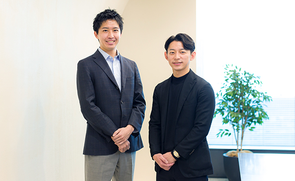
Mr. Sasagawa (left), Mr. Kitamura (center), Mr. Araki of TMRI (right)

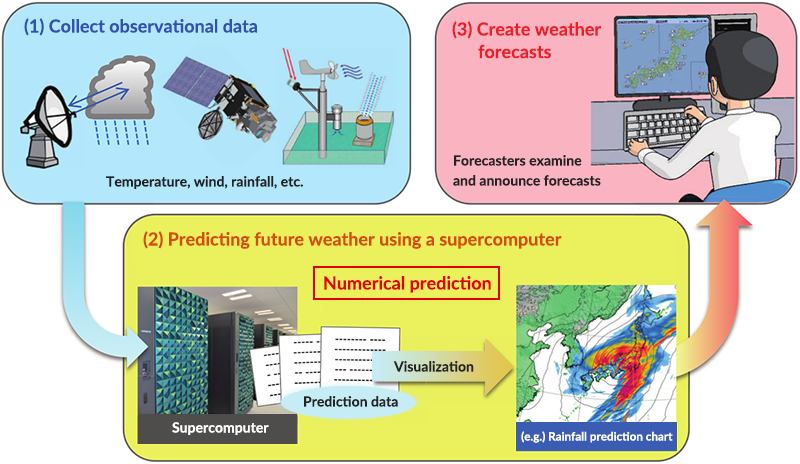
What is NWP?...
NWP technology uses various observational data to accurately product the current state of the atmosphere on a computer. Future atmospheric conditions can be predicted by using this as an initial value and performing simulation calculations of changes over time based on the laws of physics. The JMA uses this numerical prediction as basic meteorological information for weather forecasts and disaster risk reduction.
Please let us know more details of the plan.
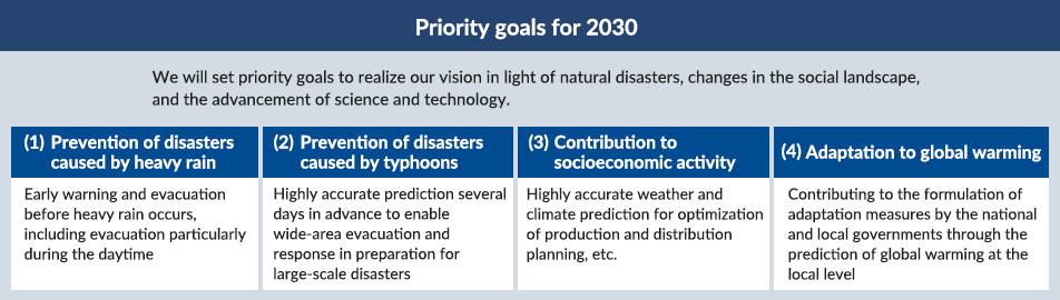
The plan is to promote technological development with the aim of achieving four key goals by 2030: (1) Prevention of disasters caused by heavy rain, (2) Prevention of disasters caused by typhoons, (3) Contribution to socioeconomic activity, and (4) Adaptation to global warming (Figure 2). The specific goals were set based on the recommendations of the advisory council, which took into account the views expressed in interviews with private companies and other stakeholders. We consider the prevention of disasters caused by heavy rain, such as in the event of a SLMCS, to be a priority issue, and we are focusing our efforts on this goal.
Prediction of SLMCSs
I would first like to ask about initiatives related to the prevention of disasters caused by heavy rain. There is a perception that SLMCS are difficult to predict because they are localized phenomena. How is prediction technology evolving?
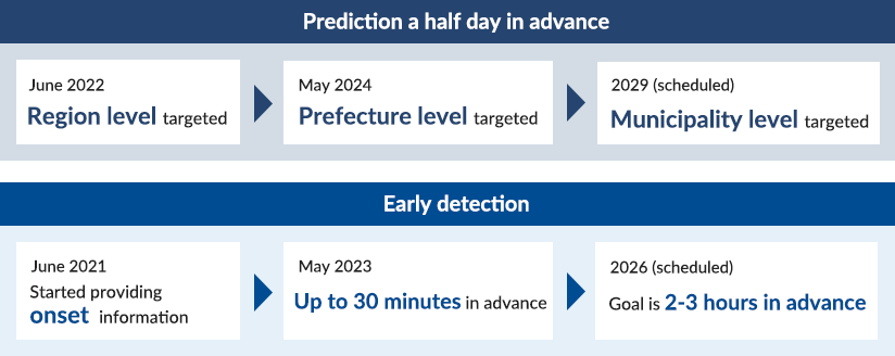
In 2022, we started an initiative to issue warnings through weather information systems approximately half a day in advance when there is a reasonably high likelihood of heavy rain caused by SLMCS. Initially, we issued warnings on the possibility of SLMCS at a regional level, such as for the Shikoku or Tokai region. Since then, we have been gradually narrowing down the target areas, and as of May 2024, we have been issuing warnings at the prefecture level.*2 The goal is to issue warnings at the municipality level by 2029. By narrowing down the target area, not only will the residents be more aware of when warnings affect them personally, but the disaster management officials of municipalities and related organizations will also be able to use them to make decisions on disaster prevention actions, such as preparing to open evacuation shelters and checking flood prevention systems.
What are the reasons behind the timing of the warnings given half a day in advance?
This is because lessons learned from past disasters have informed us of the need to be prepared during daytime for disasters caused by heavy rain that can occur at night when residents are asleep. A recent study found that during the Kyushu region's rainy season, heavy rain occurs often from night to morning*3. We therefore provide information half a day in advance so that people can be mentally prepared from an early stage and evacuate during the daytime.
I understand JMA is also working on early detection and notification of the onset of SLMCSs.
We are indeed working to issue a Weather Information/Advisory for Heavy Rain to announce the onset of a SLMCS. The aim is to provide early detection of the onset of SLMCSs so that immediate evacuation from impending danger is possible, and to inform the public of the increased disaster risk from heavy rain. Previously, the announcements were made when the criteria for SLMCS and the like were met, but by utilizing prediction technology, announcements were brought forward by up to 30 minutes since 2023*4, and our goal is to issue announcements two to three hours in advance in the future. We hope that residents will also make use of the real-time risk map service*5 provided by the JMA to keep them informed of the risks of flooding, landslides, and other natural disasters, and take action to protect their own safety.
The goals of making advance predictions at the municipality level and achieving early detection of two to three hours in advance seem quite challenging. What hurdles do you face in achieving them?
One is to improve our simulation models. Until now, we have been operating a model with a resolution of 5km that can predict up to 78 hours in advance and a model with a resolution of 2km that can predict up to 10 hours in advance. However, in 2024, the 2km resolution model is able to predict up to 18 hours in advance, enabling predictions of SLMCSs half a day in advance. We hope to further increase the resolution to 1km by 2026. The higher the resolution, the more accurately precipitation can be predicted (Figure 4), but the number of grids used also increases, which in turn increases the amount of calculation required to perform the simulation. On the other hand, calculation speed is important because predictions must meet the half-day in advance requirement. Our computing power has improved with the introduction of a new supercomputer in March 2024, and we are also investigating and developing more efficient calculation methods. In addition to simply increasing the resolution, we are also working to refine the physical processes that are included in the calculations for each grid (such as the mathematical formulae to express the changes in physical conditions, like clouds turning to ice and then rain), so that they represent more actual natural phenomena.
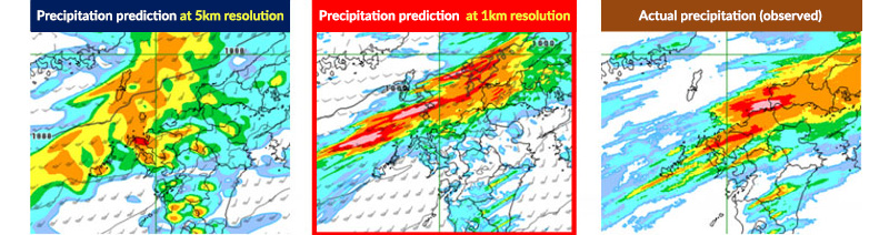
At a resolution of 1km, you can clearly see the red areas with strong precipitation. Are there other challenges?
Another is the use of observed data. To improve prediction accuracy, it is necessary to enhance the observed data, which provide the initial values for the simulations. We are deploying new equipment to enhance observed data on the amount of water vapor in the atmosphere, which is important for predicting SLMCSs. Furthermore, we will develop the next-generation geostationary meteorological satellite “Himawari-10” which incorporates the latest technology with the aim of starting operations in Japanese fiscal year 2029. Himawari-10 will play a significant role in the observations of water vapor, helping us achieve our 2030 goals. We will make full use of these observed data to obtain better initial values for our simulations.
Typhoon Forecasting
Please describe typhoon forecasts at JMA. There was a news release about forecast circles being up to 40% smaller in 2023, and it looks like the accuracy will be further improved by 2030.
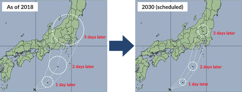
The goal for 2030 is to reduce the error in predicted typhoon tracks or the forecast circle 3 days later to 100km (Figure 5). The forecast circle previously extended from Tokyo to Hamamatsu, but our aim is to increase the accuracy such that areas around Tokyo can be pinpointed. As with SLMCSs, we are working to improve the accuracy of typhoon forecasts by both improving prediction models and strengthening observations.
Utilization of Numerical Weather Prediction (NWP) Data
You also have set contribution to socioeconomic activity as a key goal by 2030. How would you like to see NWP data utilized in society?
I hope that it will be used not only for disaster prevention, but also for forecasting product demand and for adjusting production volumes. It is difficult for business operators to make their own weather predictions based on meteorological data such as temperature and humidity. But it is relatively easy to use the results of JMA's NWP data as is in their own businesses. I hope that many business operators will make use of this data to reduce climate-related risks and improve their productivity.
I'm sure there are many business operators that would like to leverage the NWP data. How can they obtain it?
The NWP data is provided through the Japan Meteorological Business Support Center, so please refer to the center's website*6. The JMA also provides a wide range of other meteorological data in addition to the NWP data. The Weather Business Consortium (WXBC), a collaboration among industry, academia, and government aimed at expanding the use of weather data in industry, has prepared a "Weather Data User Guide"*7. I also recommend people to refer to this publication.
It seems that such data will be used more and more in industry as the accuracy of predictions improves.
Yes, I believe so. I would like people to use this data proactively, bearing in mind that NWP data is just that—a prediction—and that there is a degree of uncertainty associated with any prediction.
-
*1
-
*2Japan Meteorological Agency News Release, "New Operation of Warnings for Heavy Rain Caused by Linear Precipitation Bands About Half a Day in Advance - Warnings will be Issued at the Prefecture Level" (May 15, 2024)
Japan Meteorological Agency News Release, "Notice of Change in Start Date of New Operation of Warnings for Heavy Rainfall Caused by SLMCSs About Half a Day in Advance - Operation will Start from May 27" (May 27, 2024) -
*3
-
*4
-
*5
-
*6
-
*7
-
*Reference links only available in Japanese