Understanding and Getting Ready for When It Hails
- Sustainability
- Insurance & Risk Insights
-
*This is a reprint of an article in SENSOR, the newsletter published by the Tokio Marine Research Institute.
In April 2024, there was hail damage in Hyogo Prefecture, followed by a hailstorm in Hachioji City, Tokyo in September. It would be ideal if we could accurately to predict the time and location of coming hailstorms in advance, but unfortunately, current technology doesn’t allow us to do so.
The good news is hailstorms are seasonal in nature and in this article we will explain the mechanism of hailstorms and present information that can be used to understand the increased risk of hail.
Hail is difficult to forecast
Hail can cause extensive damage to crops and vehicles. Unfortunately, it is generally difficult to predict localized, short-term weather phenomena like hail, one of the main reasons being that such prediction would require an accurate understanding of the conditions inside cumulonimbus clouds.
Even so, understanding the mechanism of hail formation and its associated warning signs may help us take effective countermeasures.
How hail forms
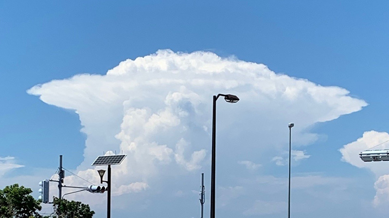
The Japan Meteorological Agency (JMA)*1defines hail as "a mass of ice 5mm or larger in diameter that falls from a cumulonimbus cloud". Incidentally, formations smaller than 5mm are called graupel ("arare" in Japanese). Cumulonimbus clouds are tall clouds that bring not only hail but also other severe weather phenomena such as tornadoes, thunderstorms, and sudden heavy rainfall. The photo shows a well-developed cumulonimbus cloud, known as an "anvil cloud", with the peak of the cloud above 10,000m and internal temperatures below freezing.
Cumulonimbus clouds contain an updraft. As the altitude increases, the temperature decreases, so the water vapor lifted by the updraft is cooled and becomes water droplets. When it is lifted even higher, it turns into ice particles. Ice particles grow when water droplets adhere to them or when they collide with other ice particles. When they become heavy, they fall to the ground. As the temperature rises during the descent, the ice particles start to melt, so that by the time they reach the ground, they have turned entirely into water. This is the normal process of rainfall. Most of the rain that falls in Japan, even in midsummer, first turns to ice in the sky before falling.
What happens, however, when the updrafts in the cumulonimbus clouds are too strong? Even if the ice particles grow due to the adhesion of water droplets or collisions with other ice crystals, they cannot fall due to the strong updraft. In addition, since the strength of the updraft is not always constant, the ice particles in the cumulonimbus clouds will repeat their vertical motion. Throughout this process, the ice particles grow even larger. If the ice particles become too large, they will not melt completely on the way down and will fall to the ground as hail stones.
Based on the above, we can see that for hail to form, it is necessary for a well-developed cumulonimbus cloud to occur, which brings about a strong updraft, and that the temperature at the top of the cumulonimbus cloud must be low. So when do such conditions come together? Actually, it’s during spring and fall.
Well-developed cumulonimbus clouds tend to form when the temperature on the ground is high. But in midsummer, the temperature in the upper atmosphere is also high, so it is difficult for the ice particles to grow large. Cumulonimbus clouds also form in winter, but they do not develop as much as when ground temperatures are warmer.
Understanding the risks of hailstorms
We know that hail tends to fall in spring and fall, but how can we detect the signs of a coming hailstorm? As mentioned above, hailstorms are difficult to predict, and the JMA does not issue forecasts for hail alone. That said, like tornadoes, lightning and sudden heavy rain, hail is a phenomenon caused by the development of cumulonimbus clouds. Therefore weather forecasts, disaster prevention meteorological information, and forecast information related to these other phenomena can also be understood as an increased risk of hail. You can also simply look at changes in the sky. Here’s some more detail on how to recognize an increased risk of hail based on (1) weather forecasts, (2) Nowcasts, and (3) changes in the sky.
(1) Weather forecasts
Even if you do not see the word "hail" on television or other weather forecasts, pay attention to key words like "unstable atmospheric conditions," "lightning," "tornadoes and other severe wind gusts," "sudden heavy rain," and "heavy rain". "Unstable atmospheric conditions" refers to a situation where there is hot, humid air near the ground and cold, dry air high up in the sky. In such cases, it is easy for developed cumulonimbus clouds with strong updrafts to form, increasing the risk of hailstorms. Note that the "hail advisory" warning doesn’t exist in Japan, but there are cases where hail is included in a lightning advisory.
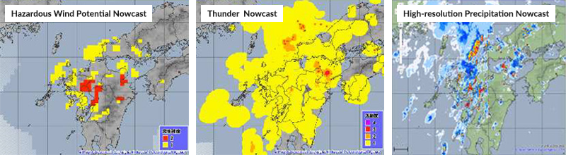
(2) Nowcasts in Japan
Nowcast is a portmanteau of the words "now" and "forecast." It’s a short-term forecast provided by the JMA with information on tornadoes, lightning, and precipitation. There are three types of Nowcasts available: Hazardous Wind Potential Nowcasts, Thunder Nowcasts, and High-resolution Precipitation Nowcasts. Tornado and thunderstorm forecasts are published up to one hour ahead, while precipitation forecasts are provided up to 30 minutes ahead. Although this is not a forecast for hailstorms, hail is also likely to fall in situations where tornadoes, thunder, and heavy localized rainfall occur, so it can also be used as a proxy for hail forecasts. These Nowcasts can be viewed by anyone on the JMA website and can also be viewed on smartphones, including when outdoors (Figure 1).
(3) Changes in the sky
When you are outdoors and you notice changes in the sky such as black clouds approaching and the surrounding area suddenly becoming dark, hearing thunder or seeing lightning, or a cold wind starting to blow, these are potentially signs of a developed cumulonimbus cloud approaching*2. Thick cumulonimbus clouds block out the sun, causing the sky to become dark even during the daytime. Lightning is thought to be caused by the collision of ice particles in the clouds, so this also coincides with the conditions under which hail is formed. Cumulonimbus clouds have not only an updraft area but also an area where cold winds blow down.
Make preparations assuming hail is difficult to predict
There are also methods for forecasting hailstorms using radar, but they have not yet reached the level where it is possible to accurately predict the location and time of the hail. At the moment, we have no alternative but to make preparations based on the assumption that hail will be difficult to predict. However, by learning about the mechanism of hail, the times and conditions when it is likely to occur, and how to obtain information on the risk of hail, and can at least become better prepared.
Author's comments
Hail is a very troublesome weather phenomenon. Yet, because it is localized and short-lived, we do not encounter it so often. Furthermore, information is very limited, partly because there is less accumulated research than for other weather phenomena such as typhoons, frontal heavy rain, and stationary linear mesoscale convective systems. For this reason, I think that there are not many people who know about the mechanism of hail and the difficulty of forecasting it. It is not easy to prepare for hail that suddenly starts to fall, but there are things you can do, such as protecting yourself when you do notice hail falling, or moving your valued possessions to a place covered with a roof. I wrote this article because I thought it was important for everyone to first learn about hail as a starting point for taking such measures.
THE TOKIO MARINE RESEARCH INSTITUTE Research Officer Daisuke Kato

-
*1
-
*2JMA: Guidelines for Informing Residents of Severe Phenomena Associated with Cumulonimbus Clouds: To Protect Residents from Tornadoes, Lightning, and Sudden Heavy Rainfall, 2015.
-
*Reference links only available in Japanese