Typhoon Season 2025: Fewer but Possibly Stronger
- Social Issues & Advancing Society
- Insurance & Risk Insights
-
*This is a reprint of an article in SENSOR, the newsletter published by the Tokio Marine Research Institute.
This year, the first typhoon of the season didn’t form until the month of June. Reports were quick to highlight that it was the fifth latest start since records began, which is significant, as overall typhoon activity is expected to drop below average. On the other hand, the decrease in number might also suggest an increase in intensity. We may witness the formation of some extremely powerful typhoons.
In this article, we look at typhoon trends for 2025 and hear from a researcher at the Japan Agency for Marine-Earth Science and Technology (JAMSTEC), whose work is at the cutting edge of typhoon prediction research.
Typhoon trends in 2025
Based on forecasts by various meteorological agencies, this year's typhoon activity may be below average, meaning we may see fewer typhoons than usual. We do, however, advise caution, as there is a possibility for the typhoons that do form to be extremely powerful. Let me explain.
The first factor we typically look at is the El Niño and La Niña phenomena, but they have not occurred this year. We expect this condition to continue through the fall*1, so their impact should be minimal.
Second, easterly winds (trade winds) are blowing stronger than normal in the equatorial tropical zone. When easterly winds are strong, high-pressure systems flowing clockwise intensify, suppressing the formation of the counterclockwise low-pressure systems associated with typhoons*2.
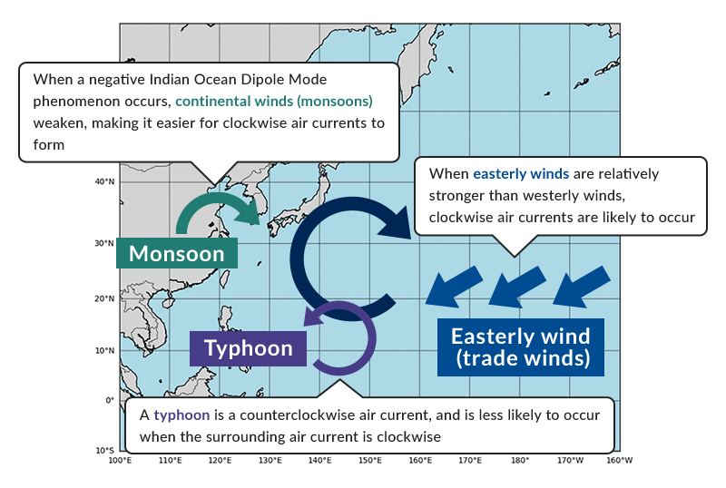
Next, sea surface temperatures in the tropical Eastern Indian Ocean are predicted to be higher than average, resulting in a negative Indian Ocean Dipole Mode. High-pressure systems are predicted to form near Taiwan, and they have a suppressive effect on the formation of typhoons*3(Figure 1).
However, when typhoon activity is low, the effect of strong winds stirring up seawater (the "stirring effect" of typhoons) is reduced. Less wind means less of a cooling effect, so sea surface temperatures remain high (Figure 2).
※
Under normal conditions, the sea surface is the warmest part of the ocean, with the temperature decreasing with depth (left figure). When a typhoon passes over the ocean, the stirring of the ocean causes the surface temperature to decrease (right figure). Note that the stirring effect is caused by multiple factors besides the direct mixing of the sea by strong winds, such as the lowering of sea surface temperatures due to increased evaporation from the sea surface when a typhoon passes, and the upwelling effect caused by the counterclockwise winds of the typhoon pulling up colder seawater from below the sea surface.
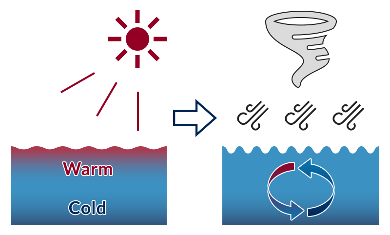
Typhoons draw their power from the thermal energy caused by sea surface evaporation. When the sea surface temperature stays high, once a typhoon forms, there is a greater risk that it will rapidly grow in power due to the ample energy thus provided. This is why, even in years when typhoons are infrequent, there is the possibility of extremely powerful typhoons forming.
Diving into the latest typhoon forecasting research
The predictions above represent the overall trend for typhoons across the entire Northwest Pacific region, including Japan. Yet ideally, we would want to know how many typhoons will actually make landfall in a given year, and if possible have that information months in advance.
We spoke with Dr. Takeshi Doi, Senior Researcher at the Japan Agency for Marine-Earth Science and Technology (JAMSTEC), who specializes in typhoon forecasting. His work enabled predictions of typhoon frequency over the summer for Okinawa and Taiwan several months in advance.*4

There have been predictions about the number of typhoons in the past. What new findings have emerged from your latest research?
Until now, it has been difficult to make seasonal forecasts narrowed down to specific regions. Through our research, we found that it is possible to predict several months in advance to some extent whether the number of tropical cyclones, including summer typhoons, in the vicinity of Okinawa and Taiwan will be higher or lower than average. Originally, we wanted to focus our predictions on specific regions, but through joint research with the TMRI, we realized once again that it would be extremely useful to be able to predict the number of typhoons approaching Japan, which prompted us to proceed with this research. (Author's note: JAMSTEC and TMRI conducted joint research on seasonal typhoon predictions in FY 2022.)
What methods did you use?
One thing we did was increase the number of members in the ensemble. An ensemble is a dataset obtained from multiple climate computer simulations. In this study, our ensemble consisted of 108 members, one of the largest in the world, making it easier to capture trends even for phenomena as infrequent as typhoons.
Second, instead of conducting a comprehensive analysis of trends across the entire Northwest Pacific as we did in the past, we divided the ocean into separate areas and focused on analyzing each one individually. This process enabled us to identify areas where predictions are comparatively easy to make.
These typhoon forecasts have proven extremely valuable for the Okinawa region. Is there scope for expanding them to the most populated Japanese island of Honshu?
Typhoons approaching Honshu are heavily influenced by prevailing weather conditions, such as wind direction and the breadth of the Pacific High anticyclone, which makes them difficult to predict several months in advance. That said, it is conceivable that prediction accuracy will improve in the future through further advances in climate model accuracy and the use of the latest AI technologies. Furthermore, by closely analyzing more predictable climate systems, as we do in this research, and applying the resulting know-how to forecasts around Honshu, we may eventually be able to make more specific predictions.
What is your outlook on the future JAMSTEC? Where else do you see your research being used?
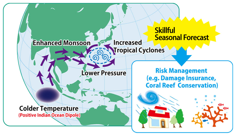
We are currently partnering with the tourism industry. Typhoons play a role in maintaining sea temperatures at a constant level through their stirring effect. When they become less frequent, sea temperatures rise, leading to significant damage to the coral reefs surrounding Okinawa and Taiwan. I hope that the results of our study can help coral reef conservation initiatives.
Furthermore, although it is difficult to predict typhoons across broad regions, forecasting is comparatively easy closer to the tropics, such as in Thailand. Since many Japanese companies have expanded into Thailand, we believe targeted forecast information for such regions will be useful.
At JAMSTEC, we remain committed to ensuring that our research findings benefit society. We would like to further explore ways to effectively collaborate with non-life insurance companies.
In closing
While 2025 may see fewer typhoons that average, we should still exercise caution, as there remains a possibility of very powerful typhoons developing.
Typhoons are notoriously difficult to predict. However, while specificity and accuracy remain limited, forecasting research is making steady progress. We may eventually see the day when weather forecasts will be as specific as, “This year, X number of typhoons will make landfall in Japan.”
-
*1Japan Meteorological Agency, "El Niño Outlook No. 393", (Accessed: 2025-06-16).
-
*2EuroTempest, Tropical Storm Risk "Extender Range Forecast for Northwest Pacific Typhoon Activity in 2025", (Accessed: 2025-06-16).
-
*3JAMSTEC, "Will the Northwest Pacific see fewer typhoons this year?", (Accessed: 2025-06-16).
-
*4JAMSTEC, "Seasonal predictability of tropical cyclone frequency around Okinawa and Taiwan—Key roles of the Indian Ocean Dipole—" (Accessed: 2025-06-16).
-
*5When sea surface temperatures in the tropical Eastern Indian Ocean are lower than in average years, seasonal winds (monsoons) blowing from the continent to the northwestern Pacific become more powerful during summer, and a low-pressure system with counterclockwise winds grows stronger near Okinawa and Taiwan. Typhoons also have a counterclockwise low-pressure circulation, which creates an environment more prone to typhoons. (Source: JAMSTEC website)
-
*Reference links only available in Japanese