Enhancing Social Resilience Through Rapid Insurance Payments Using Satellite Images
- Social Issues & Advancing Society
- Insurance & Risk Insights
In recent years, the environment surrounding the insurance industry has been changing rapidly due to the frequent occurrence of large-scale natural disasters caused by climate change. Tokio Marine Group uses satellite images to quickly grasp the extent of damage caused by natural disasters and deliver insurance payments as swiftly as possible, even when disasters strike.
For interviewed Soshi Okubo of the Strategic Promotion Team, Claims Services Department, Tokio Marine & Nichido Fire Insurance (TMNF), about the project’s background and future prospects.
The significance of working to speed up insurance payments using satellite images
Due to the impact of climate change, natural disasters are becoming more severe, and there is a need to quickly pay out casualty insurance claims to the many customers affected by these disasters to help them achieve peace of mind. TMNF has been exploring ways to assess damage more quickly and over a wider area, especially in the case of large-scale flooding, focusing on the issue that the conventional method of on-site assessment takes time.
Okubo recalls, "When I first was assigned to this project, I looked at the Cabinet Office's large-scale flood simulations and, due to the scale of the damage, I felt that the conventional approach was insufficient. In my opinion, it was essential to build a new insurance payment operation by utilizing technology such as satellites and AI to help customers achieve peace of mind as quickly as possible in the event of major disasters."
This project was launched in 2017 with the aim of swiftly identifying areas affected by large-scale disasters that are eligible for insurance payments and paying out insurance claims to customers as quickly as possible. According to Okubo, " The insurance industry as a whole needs to transform to keep pace with the increasing severity of natural disasters and technological advancement."
Use in the event of typhoons and landslides
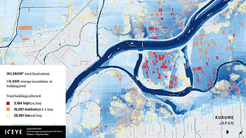
A specific example of the use of satellite images is the 2021 Atami landslide disaster. Okubo says, "In the case of the Atami landslide, by analyzing satellite data we were able to quickly determine that houses had been completely destroyed without conducting an on-site survey." "Until now, it sometimes took two weeks to assess damage because of issues like scheduling conflicts between the staff who go to the disaster area and customers. But by using satellite images, we were able to assess the damage within a few days after the disaster hit. I feel that quick action is extremely important for helping disaster victims rebuild their lives."
Furthermore, it is possible to assess damage more efficiently than before by utilizing satellite images throughout the insurance payment process. He says, looking back on the outcomes, "When a disaster occurs, we first take images using satellites and then use AI to analyze the data we've collected to assess the extent of the damage and the affected area. This allows us to quickly grasp the scale of the disaster, and it helps us establish an initial disaster response system."
Tokio Marine Group has partnered with ICEYE Ltd., a satellite data provider based in Finland, to accelerate insurance payments using satellite images. ICEYE uses satellites equipped with synthetic aperture radar (SAR) technology to acquire high-precision topographic data under any weather conditions or time of day.
Okubo added, "Optical satellites are easily affected by the weather, so there is a risk that the data needed immediately after a disaster will not be available. With ICEYE's SAR satellites, it is possible to quickly assess the extent of damage even if there are clouds or rain."
ICEYE's technology enables broad monitoring of affected areas during large-scale disasters, providing essential data that allows insurance companies, municipalities, and other concerned parties to mobilize quickly and begin recovery efforts. Okubo emphasized, "We believe our partnership with ICEYE is not only essential for delivering swift insurance payments, but also for accelerating the recovery process for the entire local community."
Through this partnership, TMNF aims to enable rapid disaster response and contribute to improving the disaster resilience of society as a whole. Going forward, TMNF plans to deepen their partnership with ICEYE and build an even more advanced disaster response system.
Provision of satellite data
TMNF plans to begin providing this service to private-sector companies and local governments for a fee while endeavoring to enhance the disaster resilience of local communities. Okubo explained the details of this initiative: "By providing the results of our satellite data analysis to private-sector companies and municipalities for a fee, we hope to support the early recovery of affected businesses and individuals. We also seek to apply the rapid assessment of damage using satellite data to accelerate supply chain management, infrastructure restoration, and issuance procedures for disaster certificates."
Strengthening the capability to respond to climate change and disasters is an issue for the insurance industry as a whole. Okubo adds, "Until now, TMNF has focused on utilizing satellite images primarily for flood response. Moving forward, we aim to expand this technology to other natural disasters, such as earthquakes and tsunamis, and by doing so, we aspire to play a leading role in enhancing the insurance industry's overall disaster response capabilities."
Disaster response with a view to the future
The initiative to accelerate insurance payments using satellite images has been applauded by external parties. It was recognized at the Insurance Asia Awards 2021, organized by the Charlton Media Group, as an initiative that has had a notable impact on the insurance industry. TMNF is taking on the challenge of transforming its traditional claims assessment framework by establishing a system that enables rapid assessment of damage and swift insurance payouts in the event of disasters.
Okubo asserts, "As technology evolves, we will continue to work toward the future by preparing a system that can respond to disasters other than flood disasters, such as damage caused by earthquakes and tsunamis."
Our vision is to further enhance the resilience of society as a whole to natural disasters by promoting initiatives to speed up disaster response while utilizing evolving technologies in collaboration with partner companies, the national government, and local municipalities.
Okubo wrapped up the interview with a few words about his vision for the future: "In addition to enhancing our ability to respond after disasters strike, I want to be able to prevent them from occurring, and if they do strike, I want to be able to minimize the damage. For example, the Cabinet Office is also conducting research into technologies to control typhoons and torrential rain. This won't be accomplished in one go, but by making use of new technologies such as satellite data, we are achieving things that were previously beyond our imagination. I hope to create a safe and secure society by making further use of technology, unbound by conventional thinking."