How Long After a Disaster Alert Should You Begin Evacuation?
- Social Issues & Advancing Society
-
*This article was originally published in “SENSOR” by the Tokio Marine Research Institute.
On May 29, 2026, a major revision to the weather warnings for disaster preparedness system issued by the Japan Meteorological Agency went into effect. Information regarding heavy rain, river flooding, landslides, and storm surges was reorganized into five simple alert levels. The new system is meant to help people more easily and intuitively understand what risks they’re under and what action is required.
While insurance is a promise to offer protection and pay claims when the unexpected occurs, the ideal outcome for everyone involved in a disaster is to mitigate damage to the greatest possible extent. Doing so requires preparedness, including a precise understanding of how and when to act in times of emergency. Familiarity with the alert system and a plan of action for each alert level are an integral part of that preparedness.
So, what should you do when an alert is issued? Here is an overview.
A more intuitive system
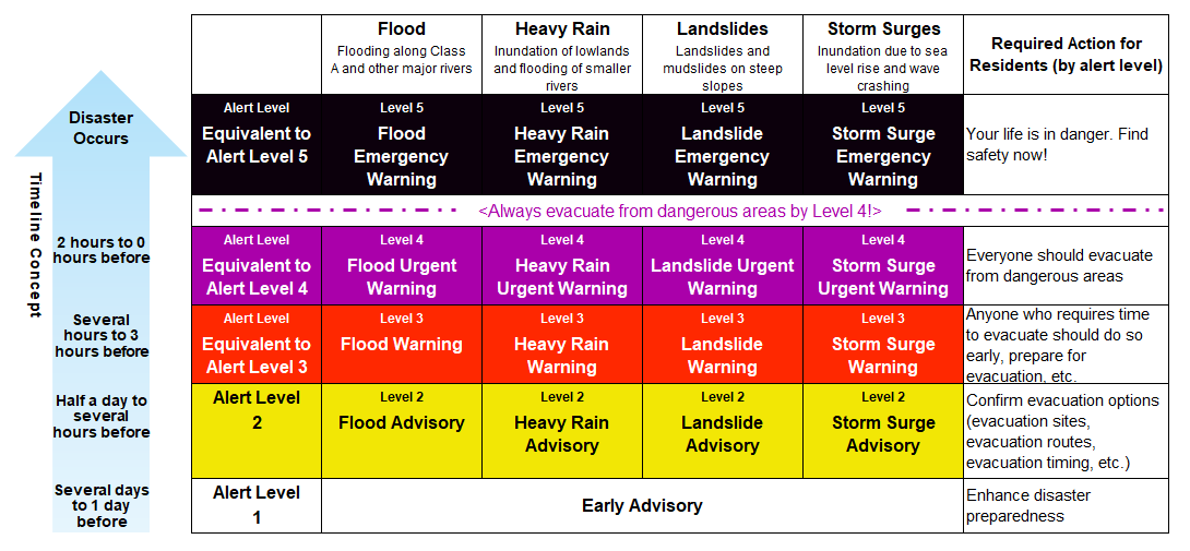
Under the new weather warnings for disaster preparedness system,*1 colors and numbers correspond to five alert levels split across types of disasters, namely heavy rain, river flooding, landslides, and storm surges. (Fig. 1).
The reason for this revision was an issue where weather warnings for disaster preparedness did not always lead to evacuation behavior. The previous system also used five alert levels, but since both warnings and advisories were included under the same alert level categories, it was difficult for people to truly understand the danger they were in, or have a clear idea of what to do upon receiving the alert.
In response to this issue, the Japan Meteorological Agency, experts, media personnel, and related organizations participated in the Committee for Weather Warnings for Disaster Preparedness*2 to discuss how to better systematize and organize weather warnings for disaster preparedness. The Study Group conducted a broad review, including a questionnaire for the public. They came to the conclusion that using numbers (i.e. a Level 5 disaster) rather than ambiguous alert names (i.e. Emergency Warning) made it easier to gauge the level of danger and act accordingly.
They landed on a five-category system with numbers and colors more closely tied to danger levels. Now, in the case of an Alert Level 4 heavy rain disaster, for example, the Agency issues an alert starting with the level number, in this case: Level 4 Heavy Rain Urgent Warning.
The importance of acting early
The levels are organized in chronological order, where the higher the level, the closer the disaster, and therefore the more urgent the required action becomes.
Level 3 (Warning) is the stage at which the elderly, people with disabilities, families with infants, and others who require time to evacuate should begin evacuating. Other people should check their evacuation sites and evacuation routes, and be ready to evacuate at any time.
Level 4 (Urgent Warning) was newly introduced with this revision, and represents the stage at which everyone affected should evacuate immediately.
Level 5 (Emergency Warning) refers to the stage at which a disaster has already occurred, or in which the life of affected persons is in danger. At this stage, leaving where you are to evacuate may be dangerous. It is therefore important to do whatever you can to protect your life without moving to an evacuation site, such as for example moving to a room on the second floor of your home, or moving away from a cliff.
The best course of action is to take necessary measures during Level 3 and Level 4, before the danger of Level 5.
Unique dangers based on location
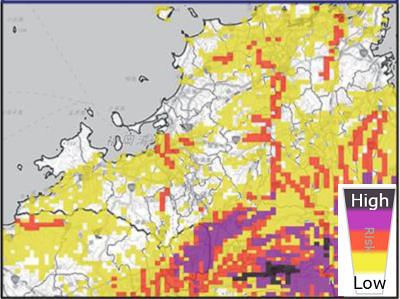
While alerts are issues at the municipal level, actual risk levels can vary depending on proximity to rivers, lowlands, highlands, mountains, cliffs and so on. Therefore, when an alert is issued, people in the affected area must assess the risk level based on their surroundings. The appropriate action to take will also change based on where you will be when the disaster occurs—such as at home, the office, at school, or in transit.
Looking for detailed information on risks and evacuation routes during a disaster may, however, take time and further delay evacuation. It is important to check hazard maps when there is no active risk to know whether, for example, your home is in a risk area for specific disasters (e.g. flooding), where and how to evacuate, the risks of traveling at night or under heavy rain, and so on.
Preparation is key
Due in part to climate change, the risk of extreme precipitation has increased in recent years. Even areas that have rarely experienced major disasters may be hit by record heavy rain. Weather warnings for disaster preparedness affects everyone, making preparedness an important part of protecting ourselves and our loved ones.
The purpose of the weather warnings for disaster preparedness system revision is to prompt action, both in individual disaster response and for the disaster preparedness of companies and organizations. To ensure the safety of their employees, businesses should have a clear vision of how to respond to each alert level in advance, including measures like deciding if employees should come into work. This revision offers companies an opportunity to reassess their business continuity plans and adapt their disaster response measures.
The most difficult thing in the event of a disaster is to take the right action. Waiting too long can make evacuation difficult or dangerous, which is why it is so important to start evacuating during Level 3 and 4 alerts, and to make necessary preparations outside of disaster situations. We should be asking ourselves on a regular basis and in detail how we would act in the event of an emergency.
Finally, we would like to share comments from Professor Katsuya Yamori of the Disaster Prevention Research Institute, Kyoto University, who chaired the Committee for Weather Warnings for disaster preparedness and provided valuable input in connection with this review of weather warnings for disaster preparedness.
Comment from Professor Katsuya Yamori, Disaster Prevention Research Institute, Kyoto University
Weather warnings for disaster preparedness serves not only to inform people about typhoons, river conditions, and other hazards, but also to encourage actions that help protect their own lives and the lives of those close to them. With this objective in mind, the recent revisions place particular emphasis on clearly communicating what actions the information is intended to prompt.
To achieve this, a unified system of levels (numerical indicators) has been introduced to express the actions people should take, regardless of the type of disaster involved, such as heavy rainfall or landslides.
This is why all of the new information categories begin with a level designation and a number. It reflects the importance of the level itself. In addition, each level is associated with a specific color code. Compared with information names written in Japanese, such as Emergency Warning, a combination of numbers and colors—for example, Level 5 (Black)—is considered more universal and easier for everyone to understand, including children and foreign residents.

There is a precedent for this approach: Japan’s seismic intensity scale (Shindo), which indicates the severity of earthquake shaking. The scale has a history spanning more than 100 years. Initially, seismic intensity was expressed only through descriptive terms such as “weak tremor” and “strong tremor.” It later evolved into a combination of numbers and descriptive terms (e.g., “Shindo 4 (strong shaking)”) and eventually into the current system that relies primarily on numerical values alone (e.g., “Shindo 3”).
Today, when people hear that a town where a friend or relative lives experienced “Shindo 6 Lower,” many can instantly form a shared understanding, such as “there may have been significant damage.” This common and immediate recognition is, in fact, a valuable social asset.
I hope that, in the near future, weather warnings for disaster preparedness will achieve a similar level of public understanding. When people hear “Level 3,” they will immediately recognize that elderly people should begin evacuation preparations, and when they hear “Level 5,” they will understand that they should avoid going outdoors unnecessarily. My hope is that the levels themselves will enable everyone to share a common understanding of the appropriate response.
— Professor Katsuya Yamori
Disaster Prevention Research Institute, Kyoto University
-
*1
-
*2
-
*Reference links only available in Japanese
Author: Takao Araki, Research Officer, THE TOKIO MARINE RESEARCH INSTITUTE