2026 Typhoon Outlook: A Potential Super El Niño
- Social Issues & Advancing Society
-
*This article was originally published in “SENSOR” by the Tokio Marine Research Institute.
While El Niño has traditionally been associated with cooler summers in Japan, recent observations and forecasts suggest that this relationship may be shifting. In addition to temperature trends from global warming, the climate pattern’s impact on typhoon activity warrants close attention, especially from a risk management perspective.
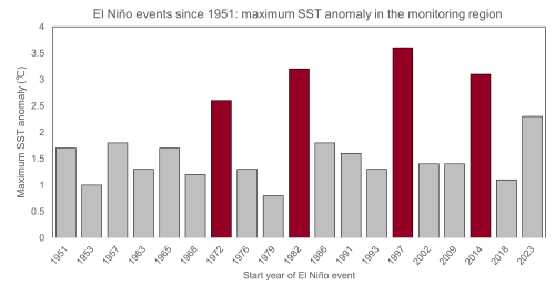
in the monitoring region during El Niño years since 1949.
Continued Heat Risk in 2026
Japan has already experienced significantly elevated temperatures in spring 2026. Western Japan has registered its highest level on record. Forecasts indicate that high temperatures are likely to persist throughout the summer, driven by atmospheric conditions such as a strengthened Asian monsoon and a northward shift of the jet stream. The possibility of an overlap between the Pacific High and Tibetan High pressure systems, which would cause a double high-pressure system, may further amplify heat risks.
Potential for an Active Typhoon Season
El Niño conditions tend to shift typhoon formation eastward, allowing storms to intensify over warm ocean waters. Forecasts suggest that 2026 could see one of the most active typhoon seasons since 2015.
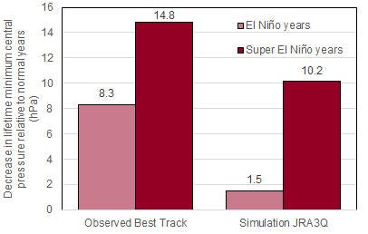
Orange bars represent El Niño years, and red bars represent Super El Niño years.
Higher bars indicate a greater decline in the average minimum central pressure compared to normal years, implying that stronger typhoons occurred.
(Source: Prepared by Tokio Marine Research Institute based on JMA data)
lifetime minimum central
pressure (LMI) of typhoons relative
to normal years
A call for preparedness
With the potential development of a Super El Niño and an active typhoon season, 2026 may present heightened natural catastrophe risks. Organizations and households alike should review preparedness measures, including but not limited to: hazard maps, evacuation plans, property maintenance, and appropriate insurance coverage.
-
*1The region bounded by 5°N–5°S and 150°W–90°W is referred to as the “El Niño monitoring area.”
The Japan Meteorological Agency defines the occurrence of an El Niño event as a condition in which the 5-month running mean of sea surface temperature anomalies in this region is +0.5°C or higher, and this condition persists for six months or longer.
While there is no universally defined threshold for a “Super El Niño,” this paper defines it as a state in which the anomaly exceeds +2.5°C. -
*2Since typhoons are relatively infrequent phenomena, there is inherent uncertainty when relying solely on observational analyses.
The reliability of the results can be improved by simultaneously using statistical analyses of simulation outputs.
Resources
-
*El Niño Outlook(Last Updated: 10 June 2026) Japan Meteorogical Agency(JMA) website: https://www.data.jma.go.jp/tcc/tcc/products/elnino/outlook.html(accessed June 10, 2026)
-
*2026 Could See A Historic Super El Niño. Here’s Why. Marshall Shepherd, Forbes: https://www.forbes.com/sites/marshallshepherd/2026/04/07/2026-could-see-a-historic-super-el-nio-heres-why/ (accessed June 10, 2026)
-
*Historical El Niño and La Niña Events JMA website: https://www.data.jma.go.jp/tcc/tcc/products/elnino/ensoevents.html(accessed June 10, 2026)
-
*Typical Weather Patterns in Japan during El Niño Events JMA website: https://www.data.jma.go.jp/cpd/data/elnino/learning/tenkou/nihon1.html (accessed June 10, 2026)
-
*What Are El Niño and La Niña? JMA website: https://www.data.jma.go.jp/cpd/data/elnino/learning/faq/whatiselnino.html (accessed June 10, 2026)
-
*Weather in Spring 2026 (March–May) JMA website: https://www.data.jma.go.jp/cpd/longfcst/seasonal/202605/202605s.html (accessed June 10, 2026)
-
*Monthly Discussion on Seasonal Climate Outlooks (No. 148) JMA website: https://www.data.jma.go.jp/tcc/tcc/products/model/monthly_discussion/latest.pdf(accessed June 25, 2026)
-
*Technical Report on Seasonal Forecasting, Vol. 2 (FY2024), Chapter 5: Characteristics of El Niño/La Niña Events and Typhoons JMA website: https://www.jma.go.jp/jma/kishou/books/kisetsu_gijutsu/kisetsu_gijutsu.html(accessed June 10, 2026)
-
*Seasonal Forecasts and Verifications Tropical Storm Risk: https://www.tropicalstormrisk.com/seasonal.html (accessed June 10, 2026)
-
*Kosaka, Y., S. Kobayashi, Y. Harada, C. Kobayashi, H. Naoe, K. Yoshimoto, M. Harada, N. Goto, J. Chiba, K. Miyaoka, R. Sekiguchi, M. Deushi, H. Kamahori, T. Nakaegawa, T. Y. Tanaka, T. Tokuhiro, Y. Sato, Y. Matsushita, and K. Onogi, 2024: The JRA-3Q reanalysis. Journal of the Meteorological Society of Japan, 102, 49–109, https://www.jstage.jst.go.jp/article/jmsj/102/1/102_2024-004/_article.2024-004.
-
*Reference links only available in Japanese
Author:Takuro Okamoto, Research Officer, THE TOKIO MARINE RESEARCH INSTITUTE