Data Visualization for Earthquake-Resilient Cities
- Resilience
Integrating Digital Twin Frameworks and Sensor Networks to Revolutionize Urban Earthquake Damage Assessment
The Great East Japan Earthquake in 2011 served as a stark reminder across Japan of the need for more sophisticated earthquake risk assessment techniques. Although disaster response teams must prepare for many types of disasters, large-scale earthquakes in urban areas present some of the greatest challenges. With thousands of buildings affected simultaneously, disaster response teams have limited time to understand where to deploy resources, all while often dealing with incomplete data. The longer it takes them to understand the situation and plan a response, the more lives are at risk.
In 2022, Nippon Koei, a member of Tokio Marine Group, partnered with Tohoku University to establish the Resilient City with Digital Twin Technologies Joint Research Division. Driven by their desire to improve earthquake response, they conducted a joint research project that ultimately led to the development of a digital twin framework.
By applying data science and IoT, this system can help local governments, disaster response teams, insurers and other stakeholders refine disaster risk maps, formulate and revise emergency evacuation routes, identify the areas and buildings where earthquake preparedness needs to be strengthened, and more quickly assess damage in the aftermath of an event.
In this piece, we will introduce digital twin technology and dive into more detail about the many benefits it represents for earthquake-prone cities.
Research Report
Introduction Movie by leading professors at Tohoku University International Research Institute of Disaster Science
Contributors
TERADA Kenjiro Professor
SAKURABA Masaaki Visiting Professor (Nippon Koei Co., Ltd. Director General of Research & Development)
Integrating simulation and sensor networks into a digital twin
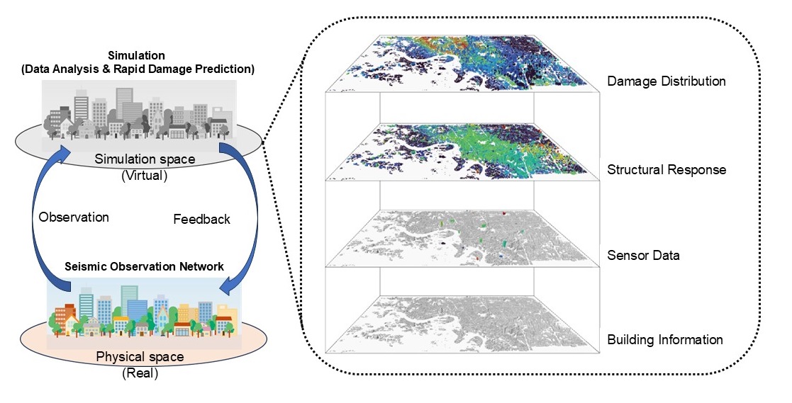
Digital twin frameworks integrate simulations with seismic sensor networks to enable real-time damage predictions across entire cities during an earthquake.
In the proposed framework, city-scale earthquake simulations are conducted before actual earthquakes occur. These simulations model how seismic waves generated along fault lines propagate through the subsurface and are transmitted to buildings. The results are then interpreted as damage levels. By analyzing these results, the spatial characteristics of damaged buildings within the city can be identified beforehand. When an actual earthquake occurs, the model can combine pre-identified spatial characteristics with real-time seismic wave data obtained through a network of installed sensors. The framework then enables the real-time evaluation of earthquake damage across the entire city.
To demonstrate the performance of the framework, Nippon Koei and Tohoku University developed a prototypical digital twin system named SAMRRAi (Seismic Assessment and Monitoring system for Real-time Risk Analysis). As shown in Figure 1, the digital twin mirrors reality by using real world information to generate a simulated space. Information such as building characteristics, ground conditions, fault models, and real-time sensor data from a seismometer network can be then exchanged between the real world and the simulated space.
From digital earthquakes to real-world damage assessment
The SAMRRAi was applied to a part of the Aoba Ward in Sendai City (Miyagi Prefecture), assuming an inland earthquake caused by movement along the Nagamachi–Rifu fault zone. The pilot analyzed 32,334 buildings across diverse urban environments—from high-rise offices near Sendai Station to residential neighborhoods and critical infrastructure—modelling 13 earthquake scenarios ranging from magnitude 6.3 to 7.5. The simulation results allowed for various risk indicators to be calculated, including not only overall structural damage, but also damage to internal building components like ceilings, interior walls, piping, sprinklers, and even furniture.
When disaster response team use only sensor data, their assessment is limited to the buildings where those sensors are installed. On the other hand, the SAMRRAi framework integrates real-time data from sensor networks with pre-simulated seismic response data and spatial characteristics to enable a comprehensive damage estimate across all buildings throughout the city—including those without sensors installed.
The pilot yielded remarkable results. With just 13 strategically placed sensors providing real-time information for less than 0.05% of buildings, SAMMRAi assessed damage across the entire ward within a 20-30% margin of error. The accuracy is sufficient to enable emergency response while employing dramatically fewer sensors than conventional approaches.
The insights provided by the framework also extend beyond the overall impact of the earthquakes, supporting resource allocation and decision-making for disaster response team, as well as risk mitigation planning to build earthquake resilience.
Tokio Marine Group actively supports research that helps address societal challenges. Enhancing society’s disaster resilience is a critical priority for our group, and we remain committed to supporting research that advances this goal.